
Home | About Us | How to Participate | Biodiversity Modules | Projects | Maps | News | Resources
NatureMapping Activities
8. Using Maps: Where Are You?
Purpose:
Students will learn how to locate the Township, Range, and Section, latitude and longitude or UTM of their homes and school.
Materials needed:
- DeLorme Atlas of your state
- 1:24,000 topographic map(s) of your school (see how to purchase)
- 1:100,000 topographic map of your general area (see how to purchase)
- Township, UTM handout, Latitude/Longitude - Advanced explanation of finding your latitude and longitude. (pdf)
- Township grid transparency (pdf)
- Mapping Conversion Chart (pdf)
- What is a Datum? (pdf)
- Whitman County Latitude/Longitude example (pdf)
Teacher’s Guide:
- Explain to students there are three ways of learning how to find a geographic location. Township/Range/Section (TRS) grid, latitude and longitude, and UTM (Universal Transverse Mercator). This exercise will allow you to practice finding TRS and Lat/Long. Topographic maps contain each of these formats.
- Topographic maps and aerial photos are not necessarily up-to-date. Locate the preparation date at the bottom of your maps. The 1:24,000 map shows dots for buildings. Locate the school on the map, and if the map is older than the school, put a dot on the map showing where the school is located.
- Show the class where the school is located on the 1:24,000, 1:100,000, and DeLorme Atlas maps.
- Break the students into groups of 2-3.
- Distribute TRS grid transparencies
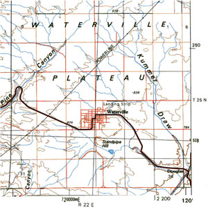
- Demonstrate how to lay them over the 1:100,000 maps (For Washington State, the DeLorme Atlas will also have the same grid on the map) lining up the section numbers 1, 6, 31, and 36 on the transparency with those numbers on the map. (see practice maps)
- Have students practice laying the grids over the maps and lining them up correctly.
- Now demonstrate how to read and record the Township and Range number.
- Repeat again, demonstrating how to write out the Section number.
- Students will then find the TRS for their school.
- Students will find their TRS for their homes.
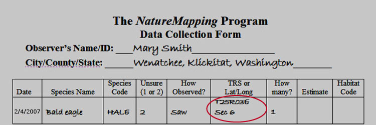
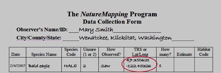
NatureMapping requirements are to report Township/Range and Section for a location. But, when you want to record sightings from specific location, such as your school or student's homes, you can also report your Latitude and Longitude. The difference is an exact location (lat/long) or a place within one square mile (section).
A. The following exercise will give students a basic understanding of topographic maps and latitude and longitude.
- Find the latitude and longitude of your school by either using a GPS unit or search online for a website.
- Discuss how lat/long is reported: Degrees, minutes, and seconds. It is a lot like telling time and you add and subtract the same way as you would calculating the difference in lat/long as you would calculating the difference telling time:
There are 60 seconds in a minute
There are 60 minutes in a degree.
47° 15'25" is read 47 degrees, 15 minutes, and 25 seconds
122° 30'10" is read 122 degrees, 30 minutes, and 10 seconds - When you report lat/long to NatureMapping, you give the location in decimal degrees.
This converts the numbers into something the computer can use to find the location on a map.
The NatureMapping Spreadsheet has a conversion formula.
It looks like this for latitude:
=B42+((((B44*60)+B46)/60)/60) - Students will look at the 1:24,000 and 1:100,000 maps and write the lat/long from the lower right corner of the maps and upper right corner. Repeat for the left corners.
- How many minutes are between the upper and lower corners (latitude) for the 1:24,000 map?
Answer: 7.5 minutes .... for the 1:100,000 map? Answer: 30 minutes - How many minutes are between the left and right corners (longitude) for the 1:24,000 map?
Answer: 7.5 minutes .... for the 1:100,000 map? Answer: 60 minutes - 1:24,000 maps are called 7.5 quad mapsÉwhy? Answer: Each size is 7.5 minutes in length.
- How many 7.5 quad maps are in a 1:100,000 map?
Answer: 30 minutes (latitude) divided by 7.5 minutes = 4
60 minutes (longitude) divided by 7.5 minutes = 8
8 x 4 = 32 maps - Where would your 7.5 quad map be located on your 1:100,000 map?
Answer: Look for "+" crosshairs on the map 7.5 minutes in and up from a corner of the map. The cross-hairs are the corners of the 7.5 quad maps. Calculate along the bottom of the map where the 7.5 minute quad would be, then along the side and look for the crosshairs. - Which way are the degrees increasing?
Answer: Latitude is increasing as you go north. Longitude is increasing as you move west. - Using the scale bar (pdf) how many miles across (longitude) is the 7.5 quad?
Answer: almost 3 miles .... Answer: (latitude) between 41/2 and 43/4 miles
B. The Student Guide has 2 sections: TRS and Latitude/Longitude. There are 11 Lat/Long examples. Some ask for only latitude or longitude, some use 1:100,000 maps and others 1:24,000 maps. The Whitman County example is one of the more complicated examples.
UTM:UTM is measured by Northings and Eastings calculated in meters. The following examples are from the Tacoma 1:100,000 map.
- Using your 1:100,000 map find the numbers along the right lower corner that look like this example: 5210000mN = This is the UTM line that is 5,210 kilometers or 5,210,000 meters N (north of the equator). 560000mE = 560,000 meters E of the UTM grid line for Zone 10 in this example.
- What is the distance in kilometers between the lower right UTM number and the next one going North? Answer: 10 What is the distance in meters? Answer: 10,000
Definitions
lat/long - Latitude/Longitude
Latitude - an imaginary line around the Earth parallel to the equator
Longitude - an imaginary great circle on the surface of the earth passing through the north and south poles at right angles to the equator
Section - In U.S. land surveying, a section is an area nominally one mile square, containing 640 acres.
Topographic map - a map showing the relief features of the earth's surface, usually by means of contour lines to show changes in elevation
Township - Survey township, sometimes called Congressional township, as used by the United States Public Land Survey System, refers to a square unit of land, that is nominally six (U.S. Survey) miles (~9.7 km) on a side. Each 36 square mile township is divided into 36 one-square mile sections.
TRS - Township/Range/Section - a grid system used for surveying land
Universal Transverse Mercator (UTM) - A grid system based upon the Transverse Mercator projection. The UTM grid is used for topographic maps and georeferencing satellite images.