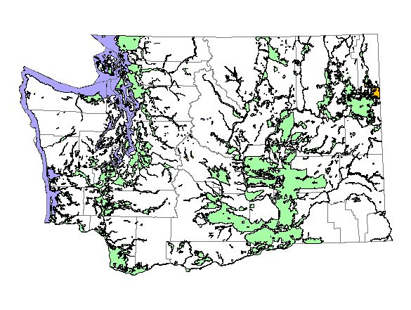
Washington Gap Analysis Project's Predicted Distribution Map
Great Blue Heron
(Ardea herodia)
|
Legend:
 = Core Habitat = Core Habitat
 = Marginal Habitat = Marginal Habitat
Breeding Range Map
The green area shows the predicted habitats for breeding only. The habitats were
identified using 1991 satellite imagery,
Breeding Bird Atlas (BBA), other datasets and experts throughout the state, as part of the Washington Gap Analysis
Project. Habitats used during non-breeding months and migratory rest-stops were not mapped.
Other maps:
- Breeding Bird Atlas
- NatureMapping observations
during breeding season
- NatureMapping observations
throughout the year
|
|
Metadata
(Data about data or how the map was made)
This species is common in marshes, mud flats, and agricultural areas at low to mid elevations on both sides of the Cascade crest. They nest colonially in trees near water and then disperse to feeding areas. Along river valleys they may be found at fairly high elevations, for example, along the Skagit River near Ross Lake. Great Blue Herons also occur at some mid-elevation lakes in Kittitas County, however, these birds may not be breeding. In eastern Washington, the Great Blue Heron is generally found from the Ponderosa Pine zone and below in suitable habitat, but it is occasionally found much higher.
In western Washington all the zones below the Silver Fir zone were core areas of use. All water/wetlands (including estuaries) were good habitat, but since herons frequently occur in open wetlands below our mapping resolution and they are often found foraging in irrigated fields, agricultural fields were included knowing there may be smaller pockets of habitat suitable for them. In eastern Washington all steppe zones, Ponderosa Pine, Interior Douglas-fir, and Oak were the core areas of use and Grand Fir, Interior Red Cedar and Interior Western Hemlock were the peripheral areas of use. However, since the heron breeding status is uncertain in these higher zones mentioned above as peripheral areas of use, it might have been more correct to exclude them entirely. The habitat modeling in the east was similar to that of western Washington, except that non-irrigated agriculture was excluded.
High elevation records are interesting, but probably do not represent breeding birds. High elevation wanderers have been recorded in the breeding season north of Darrington in Skagit County and at 5000 feet in a subalpine marsh along the Chewack River in Okanogan County. Human disturbances are a major source of nest abandonment, causing colony-wide nest failure. Disturbances with intrusive noise or habitat alteration (clearcutting, construction) are especially detrimental to heron colonies. To prevent nest failures, a 1000-foot buffer zone free of such activities is recommended. Additionally, Bald Eagles and Double-crested Cormorants are known to take over colonies and eventually drive out the herons.
Translated from the Washington Gap Analysis Bird Volume by Uchenna Bright
Text edited by Gussie Litwer
Webpage designed by Dave Lester