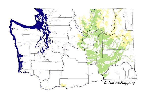
GAP Analysis Predicted Distribution Map
Tiger Salamander (Ambystoma tigrinum)
Species Code: AMTI
|
Legend:
 = Core Habitat = Core Habitat
 = Marginal Habitat = Marginal Habitat
Metadata
(Data about data or how the map was made)
Predicted Distribution
Amphibians do not migrate as some birds and mammals, so the colored areas depict the predicted range for the Tiger Salamander year-round. The habitats were identified using 1991 satellite imagery, other datasets and experts throughout the state, as part of the Washington Gap Analysis Project.
Click to enlarge distribution map
|
Distribution and Habitat Requirements
This species occurs in eastern Washington, but it is believed that the Columbia River has been a barrier to its expansion into Benton, Kittitas and
Yakima counties. Very little is known about this species in the Northwest except that it spends most of its life underground.
This species lives in the shrub-steppe. The Canyon Grassland zone is a mystery because the species is so poorly known in this region.
Models
The Columbia Basin, Northeast Corner, Okanogan Highlands and areas in the East Cascades ecoregions were selected. The Blue Mountains were excluded
from this model. In the mesic steppe zones, good habitats were open water and wetlands. Irrigated agriculture, non-forested habitats
(except sparse vegetation) and open-canopy conifer were suitable if appropriate microhabitats existed.
The drier Central Arid Steppe zones were treated similarly, except that non-forested grasslands and shrub savannas were excluded.
Closed-canopy forests were included in the Columbia Basin. The Ponderosa Pine and Oak zones were modeled like the mesic steppe zones
except that all forests were excluded and both zones were marginal.
Translated from the Washington Gap Analysis Amphibians and Reptiles Volume by Karen Dvornich
Webpage designed by Dave Lester

 = Core Habitat
 = Marginal Habitat