
Home | About Us | How to Participate | Biodiversity Modules | Projects | Maps | News | Resources
Home | About Us | How to Participate | Biodiversity Modules | Projects | Maps | News | Resources
Species Code: PADO
Legend: Breeding Range Map Metadata (Data about data or how the map was made) Click to enlarge distribution map Map with Breeding Bird Atlas records
|
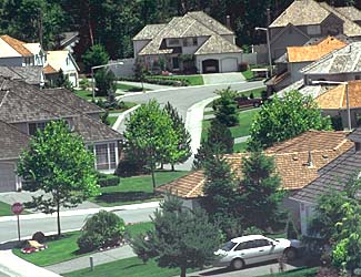
The House Sparrow is common in cities and farmlands throughout the state of Washington. In agricultural areas, this bird nests in trees or shrubs along fence rows and forages in fields. Abundant at cattle feed lots.


|
Core breeding areas were those below Silver Fir (west side) and Su-balpine Fir (east side) zones. Development and agriculture were good habitats.
Washington breeders represent the nominate European subspecies P. d. domesticus. This species first came to North America in 1851 when they were introduced in Brooklyn, New York to help control caterpillar outbreaks. House Sparrows in Washington are very dependent on development and agriculture for both food and shelter. When they occur outside the modeled distribution, they are usually associated with isolated houses or unmapped farmlands and small communities.
Translated from the Washington Gap Analysis Bird Volume by Uchenna Bright
Text edited by Gussie Litwer
Webpage designed by Dave Lester

 = Core Habitat
 = Marginal Habitat