Home | About Us | Maps | Animal Facts
GAP Analysis Predicted Distribution Map
Home | About Us | Maps | Animal Facts
Species Code: TATA
|
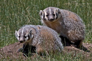
Habitat
Badgers occur in open habitats in eastern Washington including semi-desert, sagebrush, grassland, meadows, and grassy bald spots on high ridge tops. It is not known from alpine or sub-alpine parkland. Can be present in open forest (primarily Ponderosa Pine) with grassy ground cover.
Core zones are Steppe, Ponderosa Pine and Oak. In the Blue Mountains, Grand Fir and High Basalt Ridges were core. Within its range, non-forested areas are good habitat. Pasture and soil conservation areas are adequate. In steppe zones, open forest is good habitat.
Translated from the Washington Gap Analysis Mammal Volume by Dave Lester
Design by Tim Knight

 = Core Habitat
 = Marginal Habitat