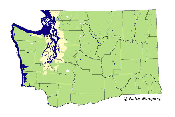
GAP Analysis Predicted Distribution Map
Bushy-tailed Woodrat (Neotoma cinerea)
Species Code: NECI
|
Legend:
 = Core Habitat = Core Habitat
 = Marginal Habitat = Marginal Habitat
Breeding Range Map
The green area shows the predicted habitats for breeding only. The habitats were
identified using 1991 satellite imagery, other datasets and experts throughout the state, as part of the Washington Gap Analysis
Project.
Click to enlarge distribution map
Map with historical museum records
|
Metadata
(Data about data or how the map was made)
Found in every county in the state except San Juan and the islands from Whidbey
north. Occur from sea level to the top of the alpine zone. Builds large nests
in talus, rock, and boulder slides; caves, mine shafts, rock outcrops with
crevices and alcoves; and old buildings other than in high-density development.
They seem to do best in open areas where the sun hits the ground, but also
occur in the habitats in closed canopy forests.
Core areas in all zones except the Puget Sound Douglas-fir zone, which is
peripheral. Bare ground, water/wetlands (except estuarine mud flats and grasslands)
and all non-forested and forested zones were good.
Translated from the Washington Gap Analysis Mammal Volume by Dave Lester
Webpage designed by Dave Lester

 = Core Habitat
 = Marginal Habitat