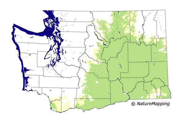
GAP Analysis Predicted Distribution Map
Fringed Myotis (Myotis thysanodes)
Species Code: MYTH
|
Legend:
 = Core Habitat = Core Habitat
 = Marginal Habitat = Marginal Habitat
Breeding Range Map
The green area shows the predicted habitats for breeding only. The habitats were
identified using 1991 satellite imagery, other datasets and experts throughout the state, as part of the Washington Gap Analysis
Project.
Click to enlarge distribution map
Map with historical museum records
|
Metadata
(Data about data or how the map was made)
This bat is associated with desert, arid grassland, and arid forests, but is rare or difficult to catch. In western Washington,
it occurs in the vicinity of Vancouver, and in drier parts of the adjacent foothills of the southwest Cascades. The most commonly
used habitat appears to be dry woodlands, but arid lands, especially those near riparian areas or forests, are also frequently used.
The Fringed Myotis roosts in caves, mines, rock crevices, and buildings, but is not particularly associated with towns or cities. It
forages by gleaning.
Core areas were in steppe, Ponderosa Pine, Oak, and Willamette Valley zones. Peripheral areas were in the Interior Douglas-fir
zone east of the Cascade crest, the Grand Fir zone in the Blue Mountains, the southern part of the Cowlitz River zone, and the
Western Hemlock zone in parts of the southwest Cascades. All habitats but developed and closed conifer forest were good.
Translated from the Washington Gap Analysis Mammal Volume by Dave Lester
Webpage designed by Dave Lester

 = Core Habitat
 = Marginal Habitat