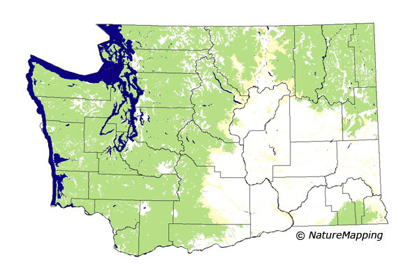
GAP Analysis Predicted Distribution Map
Long-legged Myotis (Myotis volans)
Species Code: MYVO
|
Legend:
 = Core Habitat = Core Habitat
 = Marginal Habitat = Marginal Habitat
Breeding Range Map
The green area shows the predicted habitats for breeding only. The habitats were
identified using 1991 satellite imagery, other datasets and experts throughout the state, as part of the Washington Gap Analysis
Project.
Click to enlarge distribution map
Map with historical museum records
|
Metadata
(Data about data or how the map was made)
The Long-legged Myotis is primarily a mountainous coniferous forest bat, but it may occur in the Columbia Basin along
watercourses. These bats are usually found along forest edges and among trees. Summer day roosts include buildings, crevices
in rock cliffs, fissures in the ground, and under tree bark. Maternity colonies have been found in attics, fissures in the ground,
and under tree bark. This bat is one of the few myotis bats that regularly occurs at high elevations in cool, wet, forests. It is
relatively tolerant of cool temperatures.
All forested zones were core; steppe zones were peripheral. All forests and water/wetlands (except estuaries) were good
habitats; low density development was adequate.
Although this bat is relatively more tolerant of cold temperatures than other myotis bats, it is unknown whether they
breed at high elevation.
Translated from the Washington Gap Analysis Mammal Volume by Dave Lester
Webpage designed by Dave Lester

 = Core Habitat
 = Marginal Habitat