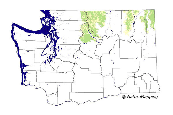
GAP Analysis Predicted Distribution Map
Lynx (Lynx canadensis)
Species Code: LYCA
|
Legend:
 = Core Habitat = Core Habitat
 = Marginal Habitat = Marginal Habitat
Breeding Range Map
The green area shows the predicted habitats for breeding only. The habitats were
identified using 1991 satellite imagery, other datasets and experts throughout the state, as part of the Washington Gap Analysis
Project.
Click to enlarge distribution map
Map with historical museum records
|
Metadata
(Data about data or how the map was made)
Lynx require a mosaic of mature (more than 200 years old), closed canopy, northern forest with a high density of downed logs,
and stumps for denning, and early successional forest stages for hunting Snowshoe Hares, its principle food. Lynx occur in
Washington from 4000 feet to treeline in the north central and northeastern parts of the state. In Okanogan County, they
prefer Lodgepole Pine and Engelmann Spruce/Subalpine Fir forests. In the northeast, they use the same type of area but also
Western Redcedar and Western Hemlock.
Core zones are the Interior Western Hemlock, Interior Redcedar, and Sub-alpine Fir zones. In the northeast Cascades, Interior
Douglas-fir was also core. Good habitat is water/wetlands, all forests in the range, and shrubland. They may come down to lower
elevations in the northeast Cascades in areas close to higher elevations. In areas where Lynx and Bobcat ranges overlap, the Lynx
will be found in the deeper snow areas.
Translated from the Washington Gap Analysis Mammal Volume by Dave Lester
Webpage designed by Dave Lester

 = Core Habitat
 = Marginal Habitat