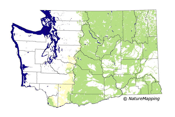
GAP Analysis Predicted Distribution Map
Northern Pocket Gopher (Thomomys talpoides)
Species Code: THTA
|
Legend:
 = Core Habitat = Core Habitat
 = Marginal Habitat = Marginal Habitat
Breeding Range Map
The green area shows the predicted habitats for breeding only. The habitats were
identified using 1991 satellite imagery, other datasets and experts throughout the state, as part of the Washington Gap Analysis
Project.
Click to enlarge distribution map
Map with historical museum records
|
Metadata
(Data about data or how the map was made)
Northern Pocket Gophers occur in meadows, grasslands, pastures, sagebrush, cultivated fields, gardens and fence rows in every
county east of the Cascade crest. Found in isolated areas west of the crest where alpine and sub-alpine meadows occur. Avoids
dense forest and shallow rocky soils but can be found up to 7000 feet in Washington.
Core zones included all those east of the Cascade crest, including Alpine/Parkland, plus the Willamette Valley zone. In the steppe,
non-forested, forests, pasture, and soil conservation reserve fields were good habitats. In the more open forest zones, non-forested,
open forest, and pastures were good habitats. Low density development was an adequate habitat in all zones.
Translated from the Washington Gap Analysis Mammal Volume by Dave Lester
Webpage designed by Dave Lester

 = Core Habitat
 = Marginal Habitat