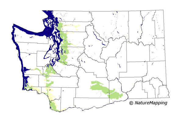
GAP Analysis Predicted Distribution Map
Nutria (Myocastor coypus)
Species Code: MYCO
Non-native Species
|
Legend:
 = Core Habitat = Core Habitat
 = Marginal Habitat = Marginal Habitat
Breeding Range Map
The green area shows the predicted habitats for breeding only. The habitats were
identified using 1991 satellite imagery, other datasets and experts throughout the state, as part of the Washington Gap Analysis
Project.
Click to enlarge distribution map
Map with historical museum records
|
Metadata
(Data about data or how the map was made)
The Nutria is an introduced species from South America brought here for fur-farming. It first escaped captivity into the Green River in 1935 and has escaped or been released and spread in the lower elevation areas from Skagit County to the Vancouver, Washington area. It is thought that their sensitivity to cold has limited their spread although some are found in Yakima County.
Low elevation zones within their range, such as Sitka Spruce, Puget Sound Douglas-fir, Willamette Valley, the Cowlitz River, Woodland/Prairies Mosaic, and the steppe zones were core. Good habitat in these zones were irrigated farmlands, and fresh/water wetlands.
Translated from the Washington Gap Analysis Mammal Volume by Dave Lester
Webpage designed by Dave Lester

 = Core Habitat
 = Marginal Habitat