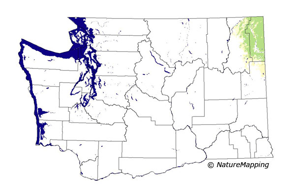
GAP Analysis Predicted Distribution Map
Red-tailed Chipmunk (Tamias ruficaudus)
Species Code: TARU
|
Legend:
 = Core Habitat = Core Habitat
 = Marginal Habitat = Marginal Habitat
Breeding Range Map
The green area shows the predicted habitats for breeding only. The habitats were
identified using 1991 satellite imagery, other datasets and experts throughout the state, as part of the Washington Gap Analysis
Project.
Click to enlarge distribution map
Map with historical museum records
|
Metadata
(Data about data or how the map was made)
Found only in the far northeastern counties of Washington, Pend Oreille, Stevens, and northern Spokane. Usually in dense
mountain coniferous forests and in openings, clearcuts, edges, and talus within those forests. Also in all habitats above
those forests up to the lower alpine zone. Generally above Ponderosa Pine and Ponderosa Pine/Douglas-fir forests. Lower limit is about 2000 feet and upper is to the highest elevation (7309 feet) in the northeast corner of the state.
Core zones were Grand Fir, Interior Western Hemlock, Interior Redcedar, Sub-alpine Fir, and Alpine/Parkland. In those zones,
non-forested and forested areas were good habitat.
Translated from the Washington Gap Analysis Mammal Volume by Dave Lester
Webpage designed by Dave Lester

 = Core Habitat
 = Marginal Habitat