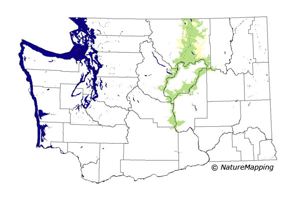
GAP Analysis Predicted Distribution Map
Spotted Bat (Euderma maculatum)
Species Code: EUMA
|
Legend:
 = Core Habitat = Core Habitat
 = Marginal Habitat = Marginal Habitat
Breeding Range Map
The green area shows the predicted habitats for breeding only. The habitats were
identified using 1991 satellite imagery, other datasets and experts throughout the state, as part of the Washington Gap Analysis
Project.
Click to enlarge distribution map
Map with historical museum records
|
Metadata
(Data about data or how the map was made)
The Spotted Bat is one of the few bats with a call audible to humans, an insect-like, high-pitched metallic click. It inhabits
western North American deserts but was not known from Washington until 1991 because of its apparent rarity, its selection of high,
sheer cliffs for roosting, and its high altitude foraging. Its presence is most dependent on the availability of high, sheer cliffs,
but it forages over a wide variety of habitats adjacent to cliffs.
Range limits were drawn to include the deepest canyons and steep cliffs along the Okanogan River, the Columbia River, the Dry
Falls canyon, and Moses Coulee. The steppe zones within its range limits were core and the Ponderosa Pine zone was peripheral.
All habitats except closed forest and high to mid-density development were good. Future surveys are likely to show that this bat
is more widespread in the Columbia Basin than indicated.
Translated from the Washington Gap Analysis Mammal Volume by Dave Lester
Webpage designed by Dave Lester

 = Core Habitat
 = Marginal Habitat