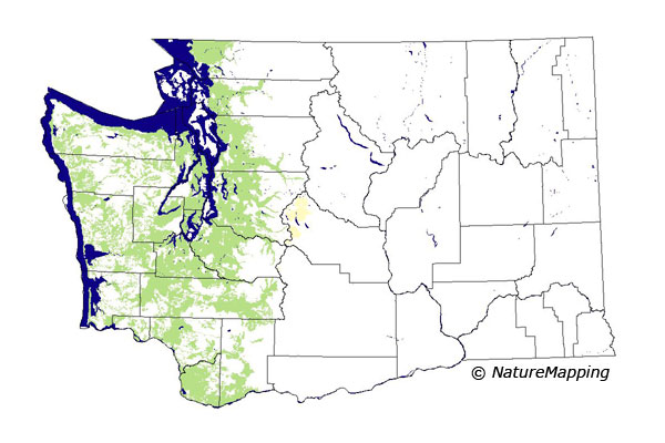
GAP Analysis Predicted Distribution Map
Townsend's Mole (Scapanus townsendii)
Species Code: SCTO
|
Legend:
 = Core Habitat = Core Habitat
 = Marginal Habitat = Marginal Habitat
Breeding Range Map
The green area shows the predicted habitats for breeding only. The habitats were
identified using 1991 satellite imagery, other datasets and experts throughout the state, as part of the Washington Gap Analysis
Project.
Click to enlarge distribution map
Map with historical museum records
|
Metadata
(Data about data or how the map was made)
Occurs in a narrower range of habitats and altitudes than the Coast Mole. All specimens were from locations below
2000 feet except in the Olympic Mountains where all were either below 2000 or above 4500 feet in sub-alpine meadows.
The high-elevation animals are a separate subspecies with no known contact down to the lowland subspecies. Townsend's Mole
occurs mainly in meadows, lawns, gardens, and cultivated areas in lowlands and in flood plains. It occurs only spottily and
uncommonly in coniferous forest and almost never in hardwood forest.
Core zones are low and mid-elevation forested zones west of the Cascade crest. In the Olympics, Silver Fir, Mountain Hemlock, and
Sub-alpine Fir are excluded but Alpine/Parkland is core. Good habitats in all zones except Alpine/Parkland are low-density development,
agriculture, fresh water/wetlands, and non-forested habitats. In the Alpine/Parkland of the Olympics, all non-forested (except sparse)
and water/wetlands are good and conifer forests are adequate.
Translated from the Washington Gap Analysis Mammal Volume by Dave Lester
Webpage designed by Dave Lester

 = Core Habitat
 = Marginal Habitat