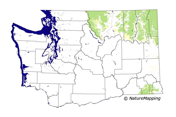
GAP Analysis Predicted Distribution Map
Western Jumping Mouse (Zapus princeps)
Species Code: ZAPR
|
Legend:
 = Core Habitat = Core Habitat
 = Marginal Habitat = Marginal Habitat
Breeding Range Map
The green area shows the predicted habitats for breeding only. The habitats were
identified using 1991 satellite imagery, other datasets and experts throughout the state, as part of the Washington Gap Analysis
Project.
Click to enlarge distribution map
Map with historical museum records
|
Metadata
(Data about data or how the map was made)
Found in coniferous and hardwood forests, moist meadows, and shrubby stream borders from sea level to the lower alpine zones.
In the alpine meadows no more than 100 feet above krummholz and along alpine streams if they are bordered by over-hanging willows.
Probably not to be found where rainfall is below 12 inches. Occurs in dry forests only where there are small streams with grassy or
herbaceous herbs.
Core zones include all forested zones and the Alpine/Parkland zone within its range. In forested zones, water/wetlands, non-forested,
and forested were good habitats where there was water. In the Palouse, found along forested watercourse areas.
Translated from the Washington Gap Analysis Mammal Volume by Dave Lester
Webpage designed by Dave Lester

 = Core Habitat
 = Marginal Habitat