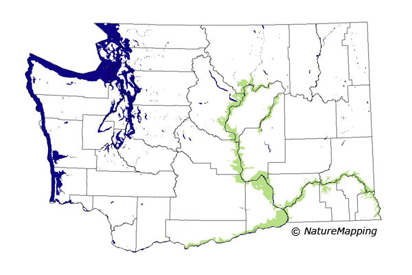
GAP Analysis Predicted Distribution Map
Western Pipistrelle (Pipistrellus hesperus)
Species Code: PIHE
|
Legend:
 = Core Habitat = Core Habitat
 = Marginal Habitat = Marginal Habitat
Breeding Range Map
The green area shows the predicted habitats for breeding only. The habitats were
identified using 1991 satellite imagery, other datasets and experts throughout the state, as part of the Washington Gap Analysis
Project.
Click to enlarge distribution map
Map with historical museum records
|
Metadata
(Data about data or how the map was made)
The Western Pipistrelle is at the northern limit of its range in Washington. Washington records for this tiny bat are
associated with deep river canyons and large water bodies in arid terrain. It probably forages over many habitats as long as
cliffs are nearby for day roosts. Its primary night roost may be sagebrush.
The range of this bat was limited to within a few miles of the largest rivers through the central and eastern Columbia Basin
(the Columbia and Snake Rivers and the lakes and rivers along the Grand Coulee), with its northern range limit in southern
Okanogan County. The Central Arid Steppe and Canyon Grassland zones were core, all others were excluded. All habitats were good
except agriculture, which was adequate. All development was excluded as habitat.
Translated from the Washington Gap Analysis Mammal Volume by Dave Lester
Webpage designed by Dave Lester

 = Core Habitat
 = Marginal Habitat