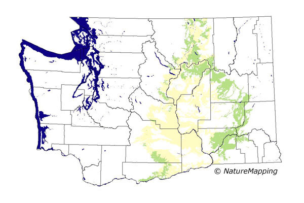
GAP Analysis Predicted Distribution Map
White-tailed Jack Rabbit (Lepus townsendii)
Species Code: LETO
|
Legend:
 = Core Habitat = Core Habitat
 = Marginal Habitat = Marginal Habitat
Breeding Range Map
The green area shows the predicted habitats for breeding only. The habitats were
identified using 1991 satellite imagery, other datasets and experts throughout the state, as part of the Washington Gap Analysis
Project.
Click to enlarge distribution map
Map with historical museum records
|
Metadata
(Data about data or how the map was made)
Occurs in much the same range as the Black-tailed Jack Rabbit but it prefers bunchgrass and also more open habitat.
Agriculture and overgrazing have eliminated much of the bunchgrass and so its numbers are diminished. Goes up into the
Okanogan drainage into Canada.
All steppe zones within the range were core areas except the Central Arid Steppe which was peripheral. In steppe zones,
non-forested habitats were good. Ponderosa and Oak zones at the edges of the steppe were peripheral. In those two zones,
good habitat included only sparsely vegetated cover, grassland, and tree savannas.
Translated from the Washington Gap Analysis Mammal Volume by Dave Lester
Webpage designed by Dave Lester

 = Core Habitat
 = Marginal Habitat