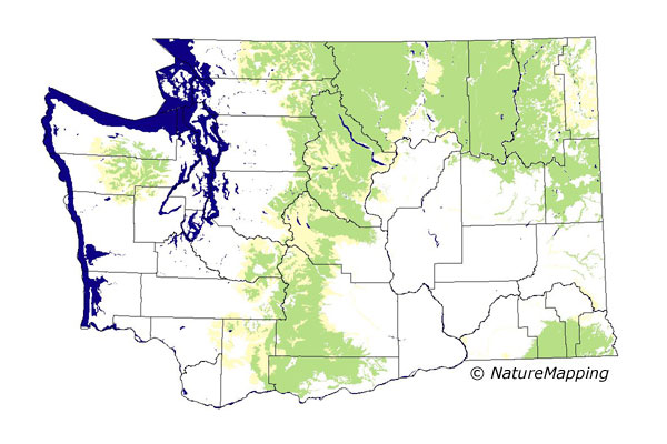
GAP Analysis Predicted Distribution Map
Yellow-pine Chipmunk (Tamias amoenus)
Species Code: TAAM
|
Legend:
 = Core Habitat = Core Habitat
 = Marginal Habitat = Marginal Habitat
Breeding Range Map
The green area shows the predicted habitats for breeding only. The habitats were
identified using 1991 satellite imagery, other datasets and experts throughout the state, as part of the Washington Gap Analysis
Project.
Click to enlarge distribution map
Map with historical museum records
|
Metadata
(Data about data or how the map was made)
This species prefers open pine forests, but is also in semi-open mixed pine, larch, and fir forest on higher slopes of the east
Cascades. It uses these forests and the talus slides and meadows or meadow-forest edges within them. On the west slope of the Cascades,
it is above dense forests in mostly alpine and sub-alpine zones and is never lower than 4000 feet. In the Olympics, the Yellow-pine
Chipmunk is confined chiefly to the stunted tree areas, meadows, and talus of the alpine and sub-alpine zones. In the southeast part
of Washington, they will apparently settle for a handful of pines in the pine stands which are in combination with considerable brush
and rock outcrops, forming a good-sized island of cover.
Sub-alpine Fir, Mountain Hemlock, and Alpine/Parkland were core zones. In those zones, non-forested and open forest habitats were good.
It is found in a multitude of forested zones but rarely in the dense closed forest areas. In all steppe zones, riparian and forested
were good habitat.
Translated from the Washington Gap Analysis Mammal Volume by Dave Lester
Webpage designed by Dave Lester

 = Core Habitat
 = Marginal Habitat