|
Metadata (Data about data or how the map was made)
Legend:
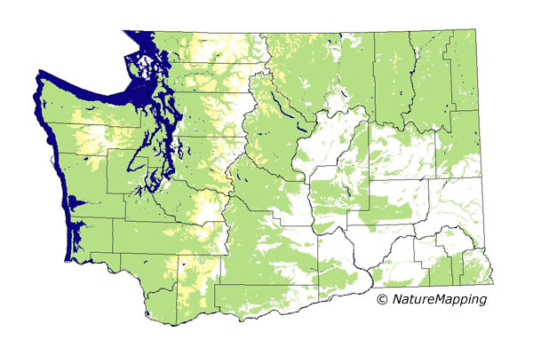
 = Core Habitat
 = Marginal Habitat
Predicted Distribution
Reptiles do not migrate as some birds and mammals, so the colored areas depict
the predicted range for the Common Garter Snake year-round. The habitats were
identified using 1991 satellite imagery, other datasets and experts throughout
the state, as part of the Washington Gap Analysis Project.
Other
maps & Information:
|
Distribution and Habitat Requirements
This species is most common in wet meadows and along water courses, but can be found in open valleys and in deep coniferous forests. Found on
San Juan, Guemes and Blakely Islands, and the islands within the Puget Sound. Open oak woodlands would also be suitable for a live-bearing reptile,
such as T. sirtalis. In the steppe zones, this species inhabits the riparian (along rivers and streams) thickets.
Models
All ecoregions were selected.
West of the Cascades, all zones up to and including Western Hemlock were core. The Silver Fir zone was marginal. East of the Cascades, all zones
up to and including Interior Redcedar were core. The Interior Western Hemlock zone was marginal.
In all forested zones, except Oak and Ponderosa Pine, forests, grasslands, shrublands, shrub and tree savannas, rivers, lakes and riparian areas were
good habitats. In Oak, Ponderosa Pine and steppe zones, only forests, open water and wetlands were good. Low density residential, cemeteries, golf
courses and parks were adequate habitats. West of the Cascades, all agriculture was adequate; east of the Cascades, irrigated agriculture was adequate habitat.
Translated from the Washington Gap Analysis Amphibians and Reptiles Volume by Karen Dvornich
Webpage designed by Dave Lester.