 |
Metadata (Data about data or how the map was made)
Legend:
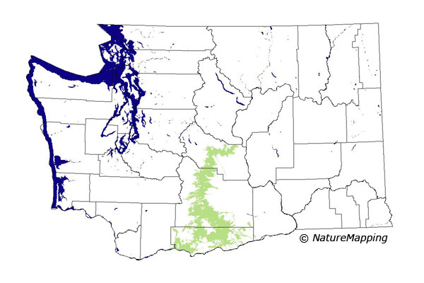
 = Core Habitat
 = Marginal Habitat
Predicted Distribution
Reptiles do not migrate as some birds and mammals, so the colored areas depict
the predicted range for the Southern Alligator Lizard year-round. The habitats
were identified using 1991 satellite imagery, other datasets and experts throughout
the state, as part of the Washington Gap Analysis Project.
Other
maps & Information:
|
Distribution and Habitat Requirements
Uta stansburiana reaches its northern limit in the warmest part of the Columbia Basin in Washington State. This species may be found on sand, rocky soil,
desert pavement and boulder slopes and is abundant on vertical cliff faces of some of the rocky desert canyons. It prefers open areas with few or no trees.
In a study on the Hanford Reservation's Rattlesnake Hills, vegetation within the lizard's range included Artemisia tridentata (big sagebrush), Poa secunda
(Sandberg bluegrass), Agropyron spicatum (Bluebunch Wheatgrass) and Bromus tectorum (Cheatgrass).
Models
The Central Arid Steppe zone was considered core in the Columbia Basin ecoregion.
Good habitats were cliffs, talus slopes, grasslands, shrub savannas and shrublands.
Translated from the Washington Gap Analysis Amphibians and Reptiles Volume by Karen Dvornich
Webpage designed by Dave Lester.