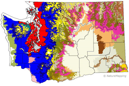
Vegetation Zones of Washington State
The vegetation zones within these ecoregions are further distinguised by soils, rainfall, fire history, elevation, aspect (i.e., if the landform is facing north, south, etc.) and slope (i.e. flat, a steep slope, etc.).
The Ponderosa Pine vegetation zone (bright purple) is where the dominant vegetation is Ponderosa Pine forests. These forests are found along the edges of the following ecoregions: Columbia Basin, Southeast, Central and Northeast Cascades, Okanogan, Northeast corner and the Blue Mountains.
The Vegetation Zones are:
- Woodland/Prairie Mosaic--localized western Washington grasslands and woodlands
- Puget Sound Douglas-fir--low, flat Puget Sound
- Cowlitz River--drainage from plains of central Lewis County to the Columbia River
- Willamette Valley--northernmost extent of the Willamette Velley
- Sitka Spruce--low-elevation coastal forest zone in the fog belt of th Pacific Ocean
- Western Hemlock--low- to mid-elevation wet forest zone covering most of western Washington
- Silver Fir--mid- to high-elevation wet forest zone covering most of western Washington
- Olympic Douglas-fir--mid-montane forest on the rain-shadowed northeast side of the Olympic Mountains
- Oak zone--Garry Oak and Oak/conifer savanna, woodlands, and forest at lower elevations in the Southeast Cascades
- Ponderosa Pine--Open Ponderosa Pine forest bordering the eastern Washington steppe
- Interior Douglas-fir--Eastern Washington forest zone above the Ponderosa Pine zone
- Grand Fir--Eastern Washington forest zone usually above the Interior Douglas-fir zone
- Interior Western Hemlock and Interior Redcedar--most mesic eastern Washington zones; in the Northeast, East Central Cascades, and Southeast Cascades, usually above the Grand Fir zone
- Subalpine Fir--subalpine forest zone up to the end of continuous timber; mostly eastern Washington, but also includes the dry subalpine forests in the Olympic Mountains rain shadow
- Blue Mountain - HIgh Open Conifers--minor Blue Mountain zone characterized by shrubs and open conifer woodland at high elevations
- Blue Mountain - High Basalt Ridges--minor Blue Mountain zone characterized by sparse vegetation on high basalt ridges
- Low-elevation Lava Flows--minor Mt. Adams zone on recent lava flows below 4000 ft.
- High-elevation Lava Flows--minor Mt. Adams zone on recent lava flows above 4000 ft.
- Blue Mountain Steppe--Steppe zone to the northeast of the Blue Mountains
- Palouse--lush meadow steppe of eastern Washington
- Wheatgrass/Fescue--grasslands to the north and south of the Snake River
- Big Sage/Fescue--Intermediate between the driest and most mesic steppe in the northeast part of the Columbia Basin
- Central Arid Steppe--driest, central part of the Columbia Basin
- Canyon Grassland--warm, dry grasslands along the Snake River and part of the Columbia Raiver
- Three-tip Sage--northern and northeastern periphery of the Columbia Basin
- Klickitat Meadow Steppe--Fescue-dominated grass and herb meadow steppe of Klickitat County
- Bitterbrush--Bitterbrush- and fescue-dominated zone in Klickitat County
- Alpine/Parkland--treeless alpine vegetation, subalpine parkland, and patchy subalpine woodlands mixed with subalpine meadows
- Permanent Ice/Snow--unvegetated tops of high mountain peaks and ridges

