Pronunciation: hi-poe-REE-ick
The study of hyporheic zones is fairly new. The hyporheic zone is generally understood to be part of the landscape that contains water of both subsurface and stream channel origin and can be visualized as 'substreams'.
The water flowing within the hyporheic zone becomes a hydrologic connection between streams and catchments. This connection becomes a dynamic bi-directional link that consist of multiple flow paths.
River and stream beds are formed of material that is often coarse and porous. Therefore, rivers, streams, wetlands and lakes leak, exchanging water with the adjacent groundwater.
Water always moves from areas of higher energy to lower energy. Scientists describe the way water moves from higher energy to areas with lower energy as moving from higher hydraulic head to areas of lower hydraulic head.
 |
Rain or snow melt, falling within a watershed, may run along the surface of the land to a stream channel (overland or Hortonian flow) or it may infiltrate into the ground. Once in the ground, it flows down hydraulic gradients to positions lower in the catchment (groundwater flow). Simply, the water flows underground in a similar fashion as it does above ground, just more slowly.
When this water intercepts a stream, it can flow out into the stream and add to the surface water flow. This is why most streams get larger in a downstream direction.
The water can also flow out of the stream channel, through the stream bed and into the groundwater. This occurs where the hydraulic head (energy) within the stream is greater than the hydraulic head in the groundwater. An extreme example of this is a desert stream which starts in the mountains and flows out into the desert, getting smaller because the higher energy flowing water moves into the lower energy groundwater until it disappears entirely.
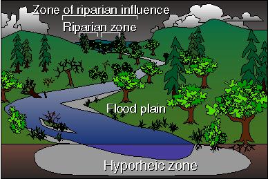
In many rivers, water moves back and forth into and out of the stream depending upon the relative head (energy) between the stream channel and the groundwater. The area where water has moved from the stream channel, back into the subsurface (below the streambed) sediments is termed the hyporheic zone. The hyporheic zone may occur beneath the stream bed or adjacent to it.
The hyporheic zone may have water that has come entirely from the stream, or it may be mixed with groundwater. Often this water will return to the stream after flowing along subsurface flowpaths. (Imagine underground streams flowing in and out of above streams.)
 |
Hyporheic zones play several important ecological roles in a river, because they are ecotones. The interactions between the surface water and groundwater make them areas of great biological and chemical activity.
Hyporheic zones may have more diverse invertebrate communities than surface streams. Organisms that live in the river may use the hyporheic zone as a refuge from floods, squeezing down into the sediment pores in the hyporheic zone.
Streams and hyporheic zones have food webs in which material and energy pass from plants and detritus to grazing and predatory animals.
Because hyporheic zones have no light, all of the organic matter that supports the food web comes in with the water as it flows through the hyporheic zone on its way back to the river. This organic matter is taken up by an active community of bacteria, protozoans (i.e., amoebae and paramecium) and meiofauna (very small insects, worms and crustaceans) that live in the pores of the sediment or as a film on the gravel itself.
This biofilm is called the epilithon. Epilithon converts the organic matter into food for larger organisms. Therefore, the epilithon serves double duty
Hyporheic zones can double the amount of organic matter removed from a stream, helping purify the water as it flows to the sea.
 |
Hyporheic zones are areas of intensive nitrogen and carbon cycling which are part of the water filtering process. Nitrogen is important because it acts as fertilizer for algae growing on the stream bed.
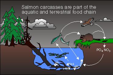
Nitrogen comes from different sources. One source is from the tissues of adult salmon spawners in small streams. Another source of nitrogen in Pacific Northwest streams is riparian zones where red alder grows. Red alder is a nitrogen fixing tree species. Red alder takes nitrogen gas from the atmosphere and converts it into organic matter. Much of this nitrogen-rich organic matter ends up in riparian soils where it can enter the hyporheic flowpaths under the floodplain. This material is converted by the epilithon into simpler forms that are used by algae.
Chemical processes within the hyporheic zone also help remove toxic materials, caused by acid mine drainage or other forms of pollution. Because they increase the productivity of streams and decrease pollution, hyporheic zones are important habitats for maintaining water quality and healthy and diverse ecosystems.
The "chemical fingerprint" is how salmon identify their home stream. They will remember this fingerprint and return to the same stream when they are adults. What part might the hyporheic zone play in determining this chemical fingerprint?
Natural and human caused disturbances may influence the location and amount of hyporheic zones in the Pacific Northwest rivers by changing the amount and location of sediment, or altering the hydraulic heads (energy) that push water through the sediment. Hyporheic zones occur where porous gravels collect in the watershed.
In the steep and unstable slopes of the Pacific Northwest rivers, the amount of sediment is changed by practices such as logging, which removes the stabilizing influence of tree roots. Without roots along a stream, there is nothing to stop soil from washing away, thereby increasing sediment in the stream channels.
Alternatively, large woody debris in streams holds back sediment that would otherwise wash downstream. Heavy rainfall may decrease the amount of sediment (and hyporheic zone) in a stream because everything would be washed away.
Urbanization also alters the amount of natural sediment that would enter a stream. Roads, parking lots and lawns close to streams do not absorb rain water. Heavy rains will runoff these impervious surfaces much faster than the streams can handle and may wash sediment away.
Other actions that may alter the distribution and activity of hyporheic zones are dam building, stream channelization, road building and water diversions. All of these actions may influence the flow of water by changing the channel shape and location of hydraulic gradients (moving from higher energy to lower energy). Changes in stream riparian zones may change the amount of detritus entering the hyporheic zones and cause problems for the hyporheic food web.