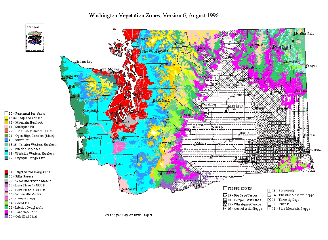
Vegetation Zones (Ecozones) of Washington State
In Washington state alone there are 13 ecological regions (outlined in black).
- Outer Olympic Peninsula--west side of the Olympic Peninsula facing the Pacific Ocean
- Inner Olympic Peninsula--east side of the Olympic Peninsula on the 'rain shadow' side of the Peninsula's mountains and hills
- Puget Sound--flat,low valley of the Puget Sound formed by the weight and scouring of glaciers during the last ice ages
- Willamette Valley--northernmost extent of the Willamette Trough that has its major portion in Oregon; includes only the lowlands around Vancouver, Washington
- Southwest Cascades--southwest Cascades from Snoqualmie Pass to the Columbia River but not including the Willlamette Valley
- Southeast Cascades--southeast Cascades from around American Ridge south to the Columbia River
- East Central Cascades--north to Lake Chelan and south to around American Ridge
- Northwest Cascades--south to Snoqualmie Pass
- Northeast Cascades--south to Lake Chelan
- Columbia Basin--steppe vegetation up to the lower timberline, but excluding the Blue Mountain Steppe zone to the north and east of the Blue Mountains
- Blue Mountains--Blue Mountains, including the Blue Mountain Steppe to the north and east of the forested Blue Mountain zones
- Okanogan Highlands--from the eastern foothills of the Okanogan valley to the crest of the Kettle Range; south to the Columbia Basin
- Northeast Corner--northeastern Washington; west to the Kettle Range; south to around Cheney
These ecoregions are distinguished by different soils, native vegetation, topography, and land use.
|
Click on the drawing to view it in more detail.
|
The vegetation zones within these ecoregions are further distinguised by soils, rainfall, fire history, elevation, aspect (i.e., if the landform is facing north, south, etc.) and slope (i.e. flat, a steep slope, etc.).
The Ponderosa Pine vegetation zone (bright purple) is where the dominant vegetation is Ponderosa Pine forests. These forests are found along the edges of the following ecoregions: Columbia Basin, Southeast, Central and Northeast Cascades, Okanogan, Northeast corner and the Blue Mountains.
The Vegetation Zones are:
- Woodland/Prairie Mosaic--localized western Washington grasslands and woodlands
- Puget Sound Douglas-fir--low, flat Puget Sound
- Cowlitz River--drainage from plains of central Lewis County to the Columbia River
- Willamette Valley--northernmost extent of the Willamette Velley
- Sitka Spruce--low-elevation coastal forest zone in the fog belt of th Pacific Ocean
- Western Hemlock--low- to mid-elevation wet forest zone covering most of western Washington
- Silver Fir--mid- to high-elevation wet forest zone covering most of western Washington
- Olympic Douglas-fir--mid-montane forest on the rain-shadowed northeast side of the Olympic Mountains
- Oak zone--Garry Oak and Oak/conifer savanna, woodlands, and forest at lower elevations in the Southeast Cascades
- Ponderosa Pine--Open Ponderosa Pine forest bordering the eastern Washington steppe
- Interior Douglas-fir--Eastern Washington forest zone above the Ponderosa Pine zone
- Grand Fir--Eastern Washington forest zone usually above the Interior Douglas-fir zone
- Interior Western Hemlock and Interior Redcedar--most mesic eastern Washington zones; in the Northeast, East Central Cascades, and Southeast Cascades, usually above the Grand Fir zone
- Subalpine Fir--subalpine forest zone up to the end of continuous timber; mostly eastern Washington, but also includes the dry subalpine forests in the Olympic Mountains rain shadow
- Blue Mountain - HIgh Open Conifers--minor Blue Mountain zone characterized by shrubs and open conifer woodland at high elevations
- Blue Mountain - High Basalt Ridges--minor Blue Mountain zone characterized by sparse vegetation on high basalt ridges
- Low-elevation Lava Flows--minor Mt. Adams zone on recent lava flows below 4000 ft.
- High-elevation Lava Flows--minor Mt. Adams zone on recent lava flows above 4000 ft.
- Blue Mountain Steppe--Steppe zone to the northeast of the Blue Mountains
- Palouse--lush meadow steppe of eastern Washington
- Wheatgrass/Fescue--grasslands to the north and south of the Snake River
- Big Sage/Fescue--Intermediate between the driest and most mesic steppe in the northeast part of the Columbia Basin
- Central Arid Steppe--driest, central part of the Columbia Basin
- Canyon Grassland--warm, dry grasslands along the Snake River and part of the Columbia Raiver
- Three-tip Sage--northern and northeastern periphery of the Columbia Basin
- Klickitat Meadow Steppe--Fescue-dominated grass and herb meadow steppe of Klickitat County
- Bitterbrush--Bitterbrush- and fescue-dominated zone in Klickitat County
- Alpine/Parkland--treeless alpine vegetation, subalpine parkland, and patchy subalpine woodlands mixed with subalpine meadows
- Permanent Ice/Snow--unvegetated tops of high mountain peaks and ridges