Hydrologic Unit Map
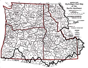
A Hydrological Unit Code (HUC) is a code used to describe a major watershed (hydrologic unit) The example shown here is a HUC map of Washington, Oregon, and Idaho. Such maps demonstrate that watersheds are not limited to political boundaries, such as counties or states.
There are 13 HUC's in Washington State and only 1 HUC is located entirely within the state. Federal agencies and other states use HUC's instead of WRIA's.
Geological Survey
Hydrologic Unit Map
Pacific Northwest
SCALE=1:2,500,000