Mapping
Knowing where you are is just as important as identifying the
wildlife.
Many important observations had to be eliminated from the statewide database, because there wasn't
enough information to accurately locate the location on a map. A major problem occurs when whoever
submits the data describes the location based on street names and local
landmarks. For example, a location described as "in my backyard, which
is down the street from the library on the corner of 312th and
Grand", is meaningless unless a city, street number, and street map is
available. A conversion template will help
with the explanations below.
There are two consistent ways of recording locations:
-
The first is using latitude and longitude.
- Latitude and longitude are marked on U.S. Geological Survey (USGS) topographic maps, DeLorme
Street Atlas and other road atlases.
Earth Tools Internet site can provide lat/long.
- Global Positioning Systems (GPS) units have become cheaper and
available to the general public. The hand-held GPS units use satellites to locate a position on the
ground and provide a digital read-out of the latitude and longitude.
Forests, canyons, and power lines can interfere with the signal and prevent some units
from locking on to the satellites. GPS units work the best in open country and on large bodies of water.
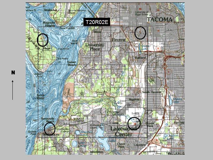
- The second way of recording locations is using the Township, Range
and Section (TRS) grids.
- Every state west of the Mississippi has a TRS grid that is used by natural resource agencies
and county planners.
There are some states east of the Mississippi that have created a TRS grid for their use.
This is the standard way of recording a location in Washington State. The Township
numbers begin with 1 at the southern part of Washington state and increase by one as you move
north. The Township number is found on the left and right edges of the USGS 1:100,000 maps, and
the DeLorme Washington State Atlas (available at all book stores).
Township 1 will be printed as "T1N" (Township 1 North).
The Range numbers begin along a meridian (a constant longitude line that
passes through a given place and the terrestrial poles) that crosses Washington by the Puget Sound.
Range numbers increase by 1 moving east or west from the meridian. The Range numbers are found on
the top and bottom edges of the USGS 1:100,000 maps and the DeLorme Washington state Atlas.
Range 1 East will be printed as R1E. (The 1:24,000 USGS maps print the TRS within the map body
and not on the edges.)
NOTE:It is important to know your TRS because your homes are referenced by city and county planners.
Homeowners can find their TRS on their mortgage papers.
In the November, 2006 elections, King County residents were asked to decide if certain properties
should be released to an agency. The locations were referenced by TRS, quarter-section. It is
doubtful many of the voters actually knew where the locations were.
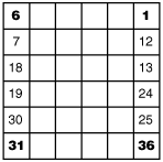
Each Township/Range consists of 36 Sections. Each Section is one square mile.
-
Section 1 begins in the northeast corner and the numbers increase as
you move west.
-
The next row of Sections increases as you move east. The Sections can
be further divided into halves:
 N-S, N-S,
 E-W or quarters: E-W or quarters:  NW,
NE, SW, SE. This allows you to more accurately define the location
of an animal. NW,
NE, SW, SE. This allows you to more accurately define the location
of an animal.
 Sections 1, 6, 31, 36 are printed on the USGS 1:100,000 and DeLorme Washington state
Atlas maps.
A transparency to find all of the Section numbers is useful to
lay over your
maps.
Sections 1, 6, 31, 36 are printed on the USGS 1:100,000 and DeLorme Washington state
Atlas maps.
A transparency to find all of the Section numbers is useful to
lay over your
maps.
Wildlife home >
|
