2. Adding the 2nd and 3rd numbers to the habitat code
The Habitat Code is built going left to right. The first number is the general habitat code.
The 2nd number describes the habitat in more detail and the 3rd number in even more detail. Usually the Habitat Code is explained beginning with the last number and ending with the first number.
Using the habitat classification below answer the following:
What is the code for a:
- light residential development?
- gravel pit with little to no plants or grass?
- Freshwater marsh surrounded by emergent (sticking out of the water) herbs/shrubs?
- Stream with conifer trees on both sides?
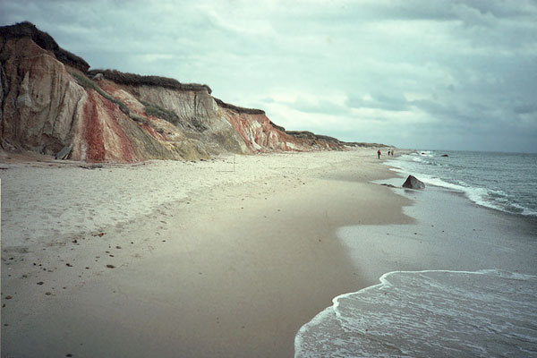
What are the codes for the 3 habitats in this picture?

1 - Unvegetated:
		10 - Rock/Talus
		11 - Cliffs
		20 - Ice/Snow (permanent)
		30 - Sand (beaches, dunes)
		40 - Bare soil (areas after floods, forest fires, recent tilling on farms)
2 - Developed
		0 - All levels of development from 10-100%
		1 - Heavy: >60% surface development / <40% of vegetation
		2 - Moderate: 30-60% surface development / ~50% vegetation
		3 - Light: 10-30% surface development / > 50% vegetation

			0 - All types of development
			1 - Residential
			2 - Industrial/Business
			3 - Mining operations: gravel pits, quarries
			4 - Roads
			5 - Grass/Shrub (i.e. cemeteries, golf courses, mowed parks)
			6 - Wooded Forests (forests/parks with mostly natural vegetation surrounded by development)
4 - Open water
		00 - All open water
		10 - Fresh water
		11 - Fresh water lakes
		12 - Municipal ponds (including reservoirs, storm water retention)
		13 - Channeled scabland ponds (Eastern Washington)
		14 - Sewage ponds
		15 - Fresh moving water (e.g. river)
		17 - Manmade canals
		18 - Irrigation ponds
		19 - Lakes surrounded by development
		20 - Salt water
		30 - Brackish water (partially salty)
5 - Wetlands:
		0 - All wetland types
		1 - Estuarine marsh (saltwater)
		2 - Freshwater marsh
		3 - Riparian (rivers and streams)
		4 - Vernal pools (pools which dry up part of the year)
		5 - Ocean beaches (vegetated)
		6 - Intermittent streams

			0 - All wetland vegetation types
			1 - Submerged/floating aquatic plants
			2 - Emergent herbs/shrubs
			3 - Trees - deciduous
			4 - Trees – conifer
			5 – Trees – mixed conifer/deciduous
			6 – Development – Heavy
			7 – Development – Medium
			8 – Development - Light
Check Answers Here >
|